
The California School Campus Database (CSCD) is now available for all public schools and colleges/universities in California.
CSCD is a GIS data set that contains detailed outlines of the lands used by public schools for educational purposes. It includes campus boundaries of schools with kindergarten through 12th grade instruction, as well as colleges, universities, and public California community colleges. Each is accurately mapped at the assessor parcel level. CSCD is the first statewide database of this information and is available for use without restriction.
California School Campus Database (CSCD) Introduction
Hosted by GreenInfo Network, learn about the recent update to the California School Campus Database (CSCD). We'll cover the history of the database, recent updates, and a new layer we've added in 2021.
WATCH: California School Campus Database (CSCD) Introduction (30:15)
READ: California School Campus Database (CSCD) Introduction (Transcript)
While data is available from the California Department of Education (CDE) at a point level, the data is simplified and often inaccurate.
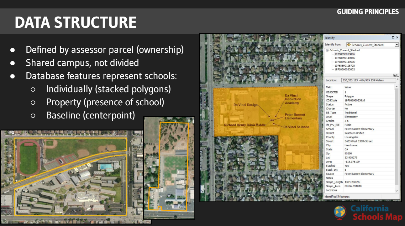
CSCD defines the entire school campus of all public schools to allow spatial analysis, including the full extent of lands used for public education in California. CSCD is suitable for a wide range of planning, assessment, analysis, and display purposes.
The lands in CSCD are defined by the parcels owned, rented, leased, or used by a public California school district for the primary purpose of educating youth. CSCD provides vetted polygons representing each public school in the state.
Data is also provided for community colleges and university lands as of the 2018 release.

The California Department of Education (CDE) places El Toro Elementary School at the Morgan City Hall and Library complex: 37.125774, -121.66265.*
The California School Campus Database (CSCD) identifies the campus nearly a mile (5,106ft) to the northeast.
EL TORRO ELEMENTARY
California School Campus Database
 Location
 Boundary
California Department of Education
 Location
 Centroid to CDE location
*2/25/16 “Public Schools and Districts” File Name: pubschls.xls; Fields: Latitude, Longitude

The California Department of Education (CDE) geocodes each school address and assigns them latitude and longitude values. Points tend to be located on the street centerline or at the edge of the campus.
The California School Campus Database (CSCD) defines the full campus of each school using assessor parcel data and aerial imagery.
University high school is 265 acres.
UNIVERSITY HIGH SCHOOL, 265 ACRES
California School Campus Database
Location
Boundary
California Department of Education
Location
Centroid to CDE location


The California Department of Education (CDE) tracks one location for charter schools despite branches in multiple clities. The site reported by CDE is often an administrative or corporate office where no student instruction is present.
The California School Campus Database (CSCD) defines all known branch campuses. Aerial imagery, assessor parcel data, and school websites are used in researching campus locations.
OPPORTUNITIES FOR LEARNING, CHARTER SCHOOL
California School Campus Database
Location
California Department of Education
Location

The California School Campus Database (CSCD) can be used alongside university campus data and parks and open space. The use of assessor parcel data for alignment minmizes silvers and gaps in analysis.
SUPPLEMENTAL DATA
School Boundary, CSCD
 University Campus, CSCD
 Parks and Public Open Space, CPAD
Available via ArcGIS Online service and MapCollaborator. All data users are responsible for reviewing and agreeing to the disclaimer statements outlined in the user manual. CSCD in no way implies permission to enter any school campus.
CSCD has been developed to meet the needs of multiple users. Actual and potential uses include:
Using CSCD? We would love to hear more about it. Send us a note to cscd@greeninfo.org.
CSCD has no ongoing funding source. Improvements are made only when funded. But you can help!
School boundary data is crucial to analysis of activities near schools. Contributions to improve the data are processed as funding is available. GreenInfo welcomes interest from those who might wish to invest in the expansion of this important data set.
CSCD is suitable for a wide range of planning, assessment, analysis, and display purposes. It should not be used as the basis for official regulatory, legal, or other such governmental actions unless reviewed by the user and deemed appropriate for their use. See the user manual for more information.
The first release of CSCD was developed by the Stanford Prevention Research Center and GreenInfo Network, with funding from the Tobacco-Related Disease Research Program grant #22RT-0142, PI: Lisa Henriksen, PhD.
CSCD 2018 was funded by a grant from the National Cancer Institute to Stanford Prevention Research Center grant 1R01-CA217165, PI: Lisa Henriksen, PhD.
CSCD 2021 was funded by the California Department of Parks and Recreation, Office of Grants and Local Services and a grant from the Chan Zuckerberg Initiative to the Center for Cities + Schools at the University of California, Berkeley grant 2020-218603, PI: Jeff Vincent, PhD.
CSCD was developed using Esri software under the Conservation Program.
CSCD is published by GreenInfo Network. Updates will be published as funding is available.